|
The Orginal Land Site
Of Croydon Airport |
|
New Barn Farm |
|
The farm appears to
be one of two eventually taken over for the development of the
airport. The land used was listed under a number of titles unfortunately
only as numbers shown on the ordnance survey maps, with only
one section specifically named. |
 |
|
(above) 'New Barn Farm', c 1910. The picture
shows the farm operating as a cereal producer shortly before
being taken over. A horse drawn cutting and threshing machine
is centre picture. It is believed that the trees to the left
of the picture are the end of what was named 'Cross Shaws'. Lavender
was grown on some farms nearby but the two do not mix, and contrary
to some suggestions there is no evidence that 'New Barn' was
involved in Lavender growing. |
|
|
|
|
A Note Concerning 'New
Barn Farm' |
|
On earlier 18th Century
maps the 'New Barn Farm' alongside 'Plough Lane' is not shown
but another farm called 'New Barn Farm' is shown not far away
on the Eastern side of 'Mitcham Common'. It is not known whether
this was reality, or as often found on early maps a mistake by
the cartographer. |
|
|
|
Woodcote
Farm |
 |
|
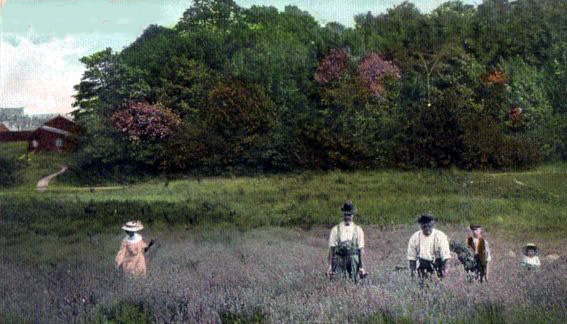
The picture
(above) from about 1908, looks to be part
of the Lavender growing 'Woodcote Farm'. The trees are possibly
either 'Roundshaw' or 'Marsh Edge Shaw'. |
|
|
The origins of the word
'Shaw' are old English of 'Norse' origin and were used to describe
either a small wood or copse, or laterly sometimes a line of
trees separating fields or lining a road. The land that was cleared
for the area which was used to build the Croydon Airport on had
three named shaws within it's boundaries before clearance, 'Cross
Shaws', 'Marsh Edge Shaw', and 'Roundshaw'. The latter name is
still in use to describe the approximate area where it was once
believed to have been. |
 |
|
The comemorative
sign near one of the original boundaries at Roundshaw. |
|
 |
 |